


LOOKINGGLASS 1 Voting District, Clinton County, Illinois
About
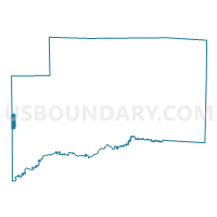
Outline

Summary
| Unique Area Identifier | 564920 |
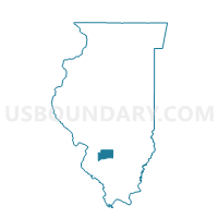
| Name | LOOKINGGLASS 1 Voting District |
| County | Clinton County |
| State | Illinois |
| Area (square miles) | 1.11 |
| Land Area (square miles) | 1.11 |
| Water Area (square miles) | 0.00 |
| % of Land Area | 100.00 |
| % of Water Area | 0.00 |
| Latitude of the Internal Point | 38.55166300 |
| Longtitude of the Internal Point | -89.70083360 |
Maps

Graphs
Select a template below for downloading or customizing gragh for LOOKINGGLASS 1 Voting District, Clinton County, Illinois


Neighbors
Neighoring Voting District (by Name) Neighboring Voting District on the Map
- LEBANON 3 Voting District, St. Clair County, IL
- LOOKINGGLASS 2 Voting District, Clinton County, IL
- LOOKINGGLASS 6 Voting District, Clinton County, IL
- MASCOUTAH 1 Voting District, St. Clair County, IL
- MASCOUTAH 4 Voting District, St. Clair County, IL
- SUGAR CREEK 3 Voting District, Clinton County, IL
Top 10 Neighboring County Subdivision (by Population) Neighboring County Subdivision on the Map
- Mascoutah township, St. Clair County, IL (8,217)
- Looking Glass township, Clinton County, IL (6,354)
- Sugar Creek township, Clinton County, IL (6,184)
- Lebanon township, St. Clair County, IL (4,538)
Top 10 Neighboring Place (by Population) Neighboring Place on the Map
Top 10 Neighboring Unified School District (by Population) Neighboring Unified School District on the Map
- Mascoutah Community Unit School District 19, IL (17,297)
- Wesclin Community Unit School District 3, IL (8,025)
- Lebanon Community Unit School District 9, IL (5,665)